Thursday, February 18, 2010

Asus Likely To Launch A 9 Inch EEE PC?


If sources are to be believed, Asus is gonna launch a 9 inch PC. Everything is still unofficial now, but sources claim that the PC is likely to be officially launched tomorrow at the Asus's press event. There's almost nothing known about the specifications yet, but it is acclaimed that the device has 2-3 hours of battery backup. The 12GB model will cost around $600 and other models with lesser capacities are also available. In the end, there are no official sources to prove what's been said, so keeps your fingers crossed till any official news comes out and clears the mist away.

DUBAI RELEASES VIDEO OF SUSPECTS IN ASSASSINATION OF HAMAS KINGPIN MAHMOUD AL-MABHOUH.......

The assassination of Hamas gun runner, Mahmoud al Mabhouh, last month in Dubai has raised a lot of flags, with most people pointing the finger towards the Mossad. The Tundra Tabloids however, believes that, while Israel's role can't be ruled out, it is also worthwhile to take a closer look at Iran.
It's very likely that Mahmoud al Mabhouh ran afoul with the Iranian regime, and with Israeli citizens' indentities having been stolen and used by the team that took Mabhouh out, that scenario looks the more plausible of the two. While one can't rule it out, it's highly unlikely that the Mossad would use Israeli identities to get into Dubai.
At any rate, offing a wanted terrorist is not a problem for the Tundra Tabloids, it's immaterial who offed Mabhouh, the main point is that this terrorist is no longer walking the streets arranging weapons to smuggle into Gaza. Thanks to Vlad for providing the background music to the vid. The ending is great. KGS

Sunday, February 7, 2010

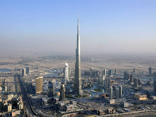
Burj Khalifa


ABSTRACT:

“Burj Khalifa is the Arab world’s tribute to the art and science of modern engineering and design. Burj Khalifa symbolizes the aesthetic unison of many cultures – from Arabia and the rest of the world.”
The base design of the building is triple-lobed footprint which was inspired by the flower Hymenocallis.
The flower has 6 spokes each representing the sides of the lobes of the tower. There are 3 elements of the tower radiating out of the central core. This structure is made with an inspiration, along with the fact that central base can keep the building stand strong when any natural calamity tries to break it down. Over 28,000 glass panels are used to cover most of the exterior, and there are 3 horizontal tracks which would help in cleaning the outer glass of whole building.
156 floors is build up with concrete, and from there above everything is made of lighter steel.
Burj Khalifa is the tallest building in the world according to the three main criteria of the Council on Tall Buildings and Urban Habitat (CTBUH). The CTBUH ranks the world’s tallest buildings based on ‘Height to Architectural Top,’ ‘Height to Highest Occupied Floor’ and ‘Height to Tip.’
Burj Khalifa employed the latest advances in wind engineering, structural engineering, structural systems, construction materials and methods. All design considerations took into account the 12,000 people who will live and work in the tower.
With a total built-up area of about 6 million sq ft, Burj Khalifa features nearly 2 million sq ft of residential space and over 300,000 sq ft of prime office space, in addition to the area occupied by the keenly awaited Armani Hotel Dubai and the Armani Residences. The tower also features modern lifestyle amenities including clubs, health and fitness facilities, gourmet restaurants and the 124th floor observation deck, 'At the Top.' Burj Khalifa is the focal point of the 500-acre ‘mega-project’ by Emaar Properties, described as the new heart of Dubai.

About the Burj Khalifa:
Originally named Burj Dubai (or Dubai Tower), the soaring skyscraper is now called Burj Khalifa, after Khalifa Bin Zayed, the president of the United Arab Emirates.
Dubai has been a showplace for innovative buildings, and the Burj Khalifa shatters world records for building height. The skyscraper is much taller than Taiwan's Taipei 101, which rises 508 meters (1,667 feet). During a time of economic slowdown, the Burj Khalifa has become an icon for wealth and progress in Dubai. No expense was spared for the building's opening ceremonies on January 4, 2010.
Burj Khalifa's Grand Vision:
World's tallest building. A living wonder. Stunning work of art. Incomparable feat of engineering. Burj Khalifa is all that. In concept and execution, Burj Khalifa has no peer.
More than just the world's tallest building, Burj Khalifa is an unprecedented example of international cooperation, symbolic beacon of progress, and an emblem of the new, dynamic and prosperous Middle East.
It is also tangible proof of Dubai's growing role in a changing world. In fewer than 30 years, this city has transformed itself from a regional centre to a global one. This success was not based on oil reserves, but on reserves of human talent, ingenuity and initiative. Burj Khalifa embodies that vision.
Mr Mohamed Alabbar, Chairman, Emaar Properties, said: "Burj Khalifa goes beyond its imposing physical specifications. In Burj Khalifa, we see the triumph of Dubai's vision of attaining the seemingly impossible and setting new benchmarks. It is a source of inspiration for every one of us in Emaar. The project is a declaration of the emirate's capabilities and of the resolve of its leaders and people to work hand in hand on truly awe-inspiring projects.
Emaar had but one inspiration, the unflagging enthusiasm set in motion by His Highness Sheikh Mohammed Bin Rashid Al Maktoum, Vice President and Prime Minister of the UAE and Ruler of Dubai, who inspires us to reach for the stars.
Construction:
Burj Khalifa was truly an international collaboration between more than 30 on-site contracting companies from nations around the world.
At the peak of construction, over 12,000 workers and contractors were on site everyday, representing more than 100 nationalities.
Building a Global Icon:
Excavation work began for Burj Khalifa in January 2004 and over the ensuing years to its completion, the building passed many important milestones on its goal to become the tallest man-made structure the world has ever seen. In just 1,325 days since excavation work started in January, 2004, Burj Khalifa became the tallest free-standing structure in the world.
Construction Highlights:
Over 45,000 m3 (58,900 cu yd) of concrete, weighing more than 110,000 tonnes were used to construct the concrete and steel foundation, which features 192 piles buried more than 50 m (164 ft) deep. Burj Khalifa's construction will have used 330,000 m3 (431,600 cu yd) of concrete and 39,000 tonnes (43,000 ST; 38,000 LT) of steel rebar, and construction will have taken 22 million man-hours.
Exterior cladding of Burj Khalifa began in May 2007 and was completed in September 2009. The vast project involved more than 380 skilled engineers and on-site technicians. At the initial stage of installation, the team progressed at the rate of about 20 to 30 panels per day and eventually achieved as many as 175 panels per day.
The tower accomplished a world record for the highest installation of an aluminium and glass façade, at a height of 512 metres. The total weight of aluminium used on Burj Khalifa is equivalent to that of five A380 aircraft and the total length of stainless steel bull nose fins is 293 times the height of Eiffel Tower in Paris.
In November, 2007, the highest reinforced concrete corewalls were pumped using 80 MPa concrete from ground level; a vertical height of 601 metres. Smashing the previous pumping record on a building of 470m on the Taipei 101; the world’s second tallest tower and the previous world record for vertical pumping of 532 metres for an extension to the Riva del Garda Hydroelectric Power Plant in 1994. The concrete pressure during pumping to this level was nearly 200 bars.
The amount of rebar used for the tower is 31,400 metric tons - laid end to end this would extend over a quarter of the way around the world.

Structure:
It is an understatement to say that Burj Khalifa represents the state-of-the-art in building design. From initial concept through completion, a combination of several important technological innovations and innovation structural design methods have resulted in a superstructure that is both efficient and robust.
 Foundation
 Podium
 Structural System
 Exterior Cladding
 Spire
 Mechanical Floors
 Window Washing Bays
 Broadcast Floors
 Mechanical, Electrical & Plumbing
 Fire Safety
 Elevators & Lifts

Foundation:
The superstructure is supported by a large reinforced concrete mat, which is in turn supported by bored reinforced concrete piles. The design was based on extensive geotechnical and seismic studies. The mat is 3.7 meters thick, and was constructed in four separate pours totaling 12,500 cubic meters of concrete. The 1.5 meter diameter x 43 meter long piles represent the largest and longest piles conventionally available in the region. A high density, low permeability concrete was used in the foundations, as well as a cathodic protection system under the mat, to minimize any detrimental effects form corrosive chemicals in local ground water.

Podium:
The podium provides a base anchoring the tower to the ground, allowing on grade access from three different sides to three different levels of the building. Fully glazed entry pavilions constructed with a suspended cable-net structure provide separate entries for the Corporate Suites at B1 and Concourse Levels, the Burj Khalifa residences at Ground Level and the Armani Hotel at Level 1.
Exterior Cladding:
The exterior cladding is comprised of reflective glazing with aluminum and textured stainless steel spandrel panels and stainless steel vertical tubular fins. Close to 26,000 glass panels, each individually hand-cut, were used in the exterior cladding of Burj Khalifa. Over 300 cladding specialists from China were brought in for the cladding work on the tower. The cladding system is designed to withstand Dubai's extreme summer heat, and to further ensure its integrity, a World War II airplane engine was used for dynamic wind and water testing. The curtain wall of Burj Khalifa is equivalent to 17 football (soccer) fields or 25 American football fields.
Structural System:
In addition to its aesthetic and functional advantages, the spiraling “Y” shaped plan was utilized to shape the structural core of Burj Khalifa. This design helps to reduce the wind forces on the tower, as well as to keep the structure simple and foster constructability. The structural system can be described as a “buttressed core”, and consists of high performance concrete wall construction. Each of the wings buttress the others via a six-sided central core, or hexagonal hub. This central core provides the torsional resistance of the structure, similar to a closed pipe or axle. Corridor walls extend from the central core to near the end of each wing, terminating in thickened hammer head walls. These corridor walls and hammerhead walls behave similar to the webs and flanges of a beam to resist the wind shears and moments. Perimeter columns and flat plate floor construction complete the system. At mechanical floors, outrigger walls are provided to link the perimeter columns to the interior wall system, allowing the perimeter columns to participate in the lateral load resistance of the structure; hence, all of the vertical concrete is utilized to support both gravity and lateral loads. The result is a tower that is extremely stiff laterally and torsionally. It is also a very efficient structure in that the gravity load resisting system has been utilized so as to maximize its use in resisting lateral loads.
As the building spirals in height, the wings set back to provide many different floor plates. The setbacks are organized with the tower’s grid, such that the building stepping is accomplished by aligning columns above with walls below to provide a smooth load path. As such, the tower does not contain any structural transfers. These setbacks also have the advantage of providing a different width to the tower for each differing floor plate. This stepping and shaping of the tower has the effect of “confusing the wind”: wind vortices never get organized over the height of the building because at each new tier the wind encounters a different building shape.
Spire:
The crowning touch of Burj Khalifa is its telescopic spire comprised of more than 4,000 tons of structural steel. The spire was constructed from inside the building and jacked to its full height of over 200 metres (700 feet) using a hydraulic pump. In addition to securing Burj Khalifa's place as the world's tallest structure, the spire is integral to the overall design, creating a sense of completion for the landmark. The spire also houses communications equipment.
Mechanical Floors:
Seven double-storey height mechanical floors house the equipment that bring Burj Khalifa to life. Distributed around every 30 storeys, the mechanical floors house the electrical sub-stations, water tanks and pumps, air-handling units etc, that are essential for the operation of the tower and the comfort of its occupants.
Window Washing Bays:
Access for the tower's exterior for both window washing and façade maintenance is provided by 18 permanently installed track and fixed telescopic, cradle equipped, building maintenance units. The track mounted units are stored in garages, within the structure, and are not visible when not in use. The manned cradles are capable of accessing the entire facade from tower top down to level seven. The building maintenance units jib arms, when fully extended will have a maximum reach of 36 meters with an overall length of approximately 45 meters. When fully retracted, to parked position, the jib arm length will measure approximately 15 meters. Under normal conditions, with all building maintenance units in operation, it will take three to four months to clean the entire exterior facade.
Broadcast and Communications Floors:
The top four floors have been reserved for communications and broadcasting. These floors occupy the levels just below the spire.
Mechanical, Electrical & Plumbing:
To achieve the greatest efficiencies, the mechanical, electrical and plumbing services for Burj Khalifa were developed in coordination during the design phase with cooperation of the architect, structural engineer and other consultant.
The tower's water system supplies an average of 946,000 litres (250,000 gallons) of water daily
At peak cooling, Burj Khalifa will require about 10,000 tons of cooling, equal to the cooling capacity provided by about 10,000 tons of melting ice
Dubai's hot, humid climate combined with the building's cooling requirements creates a significant amount of condensation. This water is collected and drained in a separate piping system to a holding tank in the basement car park
The condensate collection system provides about 15 million gallons of supplement water per year, equal to about 20 Olympic-sized swimming pools
The tower's peak electrical demand is 36mW, equal to about 360,000 100 Watt bulbs operating simultaneously

Fire Safety:
Fire safety and speed of evacuation were prime factors in the design of Burj Khalifa. Concrete surrounds all stairwells and the building service and fireman's elevator will have a capacity of 5,500 kg and will be the world's tallest service elevator. Since people can't reasonably be expected to walk down 160 floors, there are pressurized, air-conditioned refuge areas located approximately every 25 floors.

Elevators & Lifts:
Burj Khalifa will be home to 57 elevators and 8 escalators The building service/fireman's elevator will have a capacity of 5,500 kg and will be the world's tallest service elevator.
Burj Khalifa will be the first mega-high rise in which certain elevators will be programmed to permit controlled evacuation for certain fire or security events. Burj Khalifa's Observatory elevators are double deck cabs with a capacity for 12-14 people per cab. Traveling at 10 metres per second, they will have the world's longest travel distance from lowest to highest stop.
The plants in The Park of Burj Khalifa were carefully selected for their ability to grow in Dubai's challenging climate. However, the high percentage of humidity in Dubai allows for plants such as Ficus trees and the Hymenocallis to grow. Certain plants, the Evergreen trees, for example, were chosen for their capacity to provide year-round shade. Other selection criteria for the garden plants was special interest in texture, shape, form and colour of bloom.

The Park:
Inspired by Burj Khalifa's unique triple-lobed shape, The Park's 11 hectares of greenery and water features serve as both entry to Burj Khalifa and outdoor living space. The landscape design includes three distinct areas to serve each of tower's three uses: hotel, residential and office space. These exquisite grounds include a promenade along the Dubai lake, outdoor spaces, outdoor dining, prow lookout, leisure forest grove, playing area, water features and much more.
The three spaces are located at the hotel entry, residential entry and the grand terrace. The tower and pedestrian pathways link the three areas. Spectacular stone paving patterns welcome visitors at each entry. The main entry drive is circled with a palm court, water features, outdoor spaces and a forest grove above. The grand terrace features garden spaces, all-around pedestrian circulation, custom site furnishings, a functional island and a lake edge promenade. The grand water terrace is composed of several levels that step down towards the lake's edge. The water terraces provide further visual interest by reflecting the tower on their surfaces. The landscape design includes six major water features: the main entry fountain, hotel entry fountain, residential entry fountain, the grand water terrace, children's fountain pool and the sculptural fountain.
Green Irrigation:
The gardens are partly irrigated with water collected through Burj Khalifa’s Condensate Collection System. Hot and humid Dubai outside air, combined with the tower’s cooling requirements result in a significant amount of condensation of moisture from the air. This water, stored in the basement car park, provides about 15 million gallons of supplemental water per year, the equivalent to nearly 20 Olympic-sized swimming pools.
Inspired Design:
While it is superlative in every respect, it is the unique design of Burj Khalifa that truly sets it apart. The centrepiece of this new world capital attracted the world's most esteemed designers to an invited design competition.
Ultimately, the honour of designing the world's tallest tower was awarded the global leader in creating ultra-tall structures, the Chicago office of Skidmore, Owings & Merrill LLP (SOM) with Adrian Smith FAIA, RIBA, consulting design Partner. The selected design was subject to an extensive peer review program to confirm the safety and effectiveness of the structural systems.
• Architecture
• Wind Testing
• Floor Plan
• Interiors
• Artwork

Architecture:
The architecture features a triple-lobed footprint, an abstraction of the Hymenocallis flower. The tower is composed of three elements arranged around a central core. The modular, Y-shaped structure, with setbacks along each of its three wings provides an inherently stable configuration for the structure and provides good floor plates for residential. Twenty-six helical levels decrease the cross section of the tower incrementally as it spirals skyward.
The central core emerges at the top and culminates in a sculpted spire. A Y-shaped floor plan maximizes views of the Arabian Gulf. Viewed from the base or the air, Burj Khalifa is evocative of the onion domes prevalent in Islamic architecture.
Wind Tunnel Testing:
Over 40 wind tunnel tests were conducted on Burj Khalifa to examine the effects the wind would have on the tower and its occupants. These ranged from initial tests to verify the wind climate of Dubai, to large structural analysis models and facade pressure tests, to micro-climate analysis of the effects at terraces and around the tower base. Even the temporary conditions during the construction stage were tested with the tower cranes on the tower to ensure safety at all times.
Stack effect or chimney effect is a phenomenon that effects super-tall building design, and arises from the changes in pressure and temperature with height. Special studies were carried on Burj Khalifa to determine the magnitude of the changes that would have to be dealt with in the building design.
Floor Plan:
Concourse level to level 8 and level 38 and 39 will feature the Armani Hotel Dubai. Levels 9 to 16 will exclusively house luxurious one and two bedroom Armani Residences.
Floors 45 through 108 are private ultra-luxury residences. The Corporate Suites occupy fill most of the remaining floors, except for level 122 which houses a restaurant and level 124, the tower's public observatory.
For the convenience of home owners, the tower has been divided in to sections with exclusive Sky Lobbies on Levels 43, 76 and 123 that feature state-of-the-art fitness facilities including a Jacuzzis on Level 43 and 76. The Sky Lobbies on 43 and 76 additionally house swimming pools and a recreational room each that can be utilized for gatherings and lifestyle events. Offering an unparalleled experience, both pools open to the outside offering residents the option of swimming from inside to the outside balcony.
Other facilities for residents include a Residents' Library, and Burj Khalifa Gourmet Market, a gourmet convenience store and meeting place for the residents. Valet parking will be provided for guests and visitors.
Interiors:
The interior design of Burj Khalifa public areas was also done by the Chicago office of Skidmore, Owings & Merrill LLP and was led by award-winning designer Nada Andric. It features glass, stainless steel and polished dark stones, together with silver travertine flooring, Venetian stucco walls, handmade rugs and stone flooring. The interior were inspired by local cultural while staying mindful of the buildingís status as a global icon and residence.
Artwork:
Over 1,000 pieces of art from prominent Middle Eastern and international artists will adorn Burj Khalifa and the surrounding Emaar Boulevard. Many of the pieces were specially commissioned by Emaar to be a tribute to the spirit of global harmony. The pieces were selected as a means of linking cultures and communities, symbolic of Burj Khalifa being an international collaboration.

Burj Khalifa Height, Facts & Figures:
Bringing Burj Khalifa to life required a combination of visionary ideals and solid science. In the process, the project amassed an awe-inspiring number of facts, figures, and statistics.
World Records:
At over 800 meters (2625 feet) and more than 160 stories, Burj Khalifa holds the following records:
• Tallest building in the world
• Tallest free-standing structure in the world
• Highest number of stories in the world
• Highest occupied floor in the world
• Highest outdoor observation deck in the world
• Elevator with the longest travel distance in the world
• Tallest service elevator in the world

Tallest of the Super tall:
Not only is Burj Khalifa the world’s tallest building, it has also broken two other impressive records: tallest structure, previously held by the KVLY-TV mast in Blanchard, North Dakota, and tallest free-standing structure, previously held by Toronto’s CN Tower. The Chicago-based Council on Tall Buildings and Urban Habitat (CTBUH) has established 3 criteria to determine what makes a tall building tall. Burj Khalifa wins by far in all three categories.
Height to architectural top:
Height is measured from the level of the lowest, significant, open-air, pedestrian entrance to the architectural top of the building. This includes spires, but does not include antennae, signage, flagpoles or other functional-technical equipment. This measurement is the most widely used and is used to define the Council on Tall Buildings and Urban Habitat rankings of the Tallest Buildings in the World.

Highest occupied floor:
Height is measured from the level of the lowest, significant, open-air, pedestrian entrance to the highest continually occupied floor within the building. Maintenance areas are not included.

Height to tip:
Height is measured from the level of the lowest, significant, open-air, pedestrian entrance to the highest point of the building, irrespective of material or function of the highest element. This includes antennae, flagpoles, signage and other functional-technical equipment.
Burj Khalifa Construction Timeline:
 January 2004 Excavation started
 February 2004 Piling started
 March 2005 Superstructure started
 June 2006 Level 50 reached
 January 2007 Level 100 reached
 March 2007 Level 110 reached
 April 2007 Level 120 reached
 May 2007 Level 130 reached
 July 2007 Level 141 reached - world's tallest building
 September 2007 Level 150 reached - world's tallest free-standing structure
 April 2008 Level 160 reached - world's tallest man-made structure
 January 2009 Completion of spire - Burj Khalifa tops out
 September 2009 Exterior cladding competed
 January 2010 Official launch ceremony


Burj Khalifa - how it compares
With swimming pools on floors 43 and 76, and plans for the world's highest mosque on the 158th floor, the 20 billion dollars 'superscraper' dwarfs the world's previous tallest building, the 508m Tower 101 in Taipei


Burj Khalifa achieved the distinction of being the world's tallest structure – surpassing the KVLY-TV mast (628.8 metres; 2,063 ft) in North Dakota, USA – 1,325 days after excavation work started in January 2004. The tower also beats the 31-year-old record of CN Tower, which at 553.33 metres (1,815.5 ft) had been the world’s tallest free-standing structure on land since 1976.


A few facts to note -
 From the top of Burj dubai, area all around of upto 80 kms can be seen.
 3,30,000 cubic meters of concrete was used, which equals the weight of 100,000 elephants.
 To reach from the ground floor to the top most floor, it would take just a minute time.
 An office space in Burj Dubai costs $4000 per sq.ft.
 More than 1000 residential apartments are build in it, and there are 57 elevators installed.
 The address fo Burj Dubai – P.O. Box No. 1, Burj Dubai, Dubai
Conclusion:
More than just the world's tallest building, Burj Khalifa is an unprecedented example of international cooperation, symbolic beacon of progress, and an emblem of the new, dynamic and prosperous Middle East.
It is also tangible proof of Dubai's growing role in a changing world. In fewer than 30 years, this city has transformed itself from a regional centre to a global one. This success was not based on oil reserves, but on reserves of human talent, ingenuity and initiative. Burj Khalifa embodies that vision.

Unmanned Aerial Vehicle


ABSTRACT:

The UAV is an acronym for Unmanned Aerial Vehicle, which is an aircraft with no pilot on board. UAVs can be remote controlled aircraft (e.g. flown by a pilot at a ground control station) or can fly autonomously based on pre-programmed flight plans or more complex dynamic automation systems. UAVs are currently used for a number of missions, including reconnaissance and attack roles. For the purposes of this article, and to distinguish UAVs from missiles, a UAV is defined as being capable of controlled, sustained level flight and powered by a jet or reciprocating engine. In addition, a cruise missile can be considered to be a UAV, but is treated separately on the basis that the vehicle is the weapon. The acronym UAV has been expanded in some cases to UAVS (Unmanned Aircraft Vehicle System). The FAA has adopted the acronym UAS (Unmanned Aircraft System) to reflect the fact that these complex systems include ground stations and other elements besides the actual air vehicles.
They have been used in a reconnaissance and intelligence-gathering role since the 1950s, and more challenging roles are envisioned, including combat missions. Since 1964 the Defense Department has developed 11 different UAVs, though due to acquisition and development problems only 3 entered production. The US Navy has studyied the feasibility of operating VTOL UAVs since the early 1960s, the QH-50 Gyrodyne torpedo-delivery drone being an early example. However, high cost and technological immaturity have precluded acquiring and fielding operational VTOL UAV systems.
By the early 1990s DOD sought UAVs to satisfy surveillance requirements in Close Range, Short Range or Endurance categories. Close Range was defined to be within 50 kilometers, Short Range was defined as within 200 kilometers and Endurance as anything beyond. By the late 1990s, the Close and Short Range categories were combined, and a separate Shipboard category emerged. The current classes of these vehicles are the Tactical UAV and the Endurance category.
Officially, the term 'Unmanned Aerial Vehicle' was changed to 'Unmanned Aircraft System' to reflect the fact that these complex systems include ground stations and other elements besides the actual air vehicles. The term UAS, however, is not widely used as the term UAV has become part of the modern lexicon.


History:
The earliest UAV was A. M. Low's "Aerial Target" of 1916. A number of remote-controlled airplane advances followed, including the Hewitt-Sperry Automatic Airplane, during and after World War I, including the first scale RPV (Remote Piloted Vehicle), developed by the film star and model airplane enthusiast Reginald Denny in 1935. More were made in the technology rush during the Second World War; these were used both to train antiaircraft gunners and to fly attack missions. Jet engines were applied after WW2, in such types as the Teledyne Ryan Firebee I of 1951, while companies like Beechcraft also got in the game with their Model 1001 for the United States Navy in 1955. Nevertheless, they were little more than remote-controlled airplanes until the Vietnam Era.
During the Yom Kippur War, Syrian missile batteries in Lebanon caused heavy damages to Israeli fighter jets. As a result, Israel developed the first modern UAV. The images provided by these UAVs helped Israel to completely neutralize the Syrian air defenses at the start of the 1982 Lebanon War, resulting in no pilots downed.
With the maturing and miniaturization of applicable technologies as seen in the 1980s and 1990s, interest in UAVs grew within the higher echelons of the US military. UAVs were seen to offer the possibility of cheaper, more capable fighting machines that could be used without risk to aircrews. Initial generations were primarily surveillance aircraft, but some were armed (such as the MQ-1 Predator, which utilized AGM-114 Hellfire air-to-ground missiles). An armed UAV is known as an unmanned combat air vehicle (UCAV).
As a tool for search and rescue, UAVs can help find humans lost in the wilderness, trapped in collapsed buildings, or adrift at sea.
What Is a UAV?
The term UAV is an abbreviation of Unmanned Aerial vehicle, meaning aerial vehicles which operate without a human pilot. UAVs are commonly used in both the military and police forces in situations where the risk of sending a human piloted aircraft is unacceptable, or the situation makes using a manned aircraft impractical.
One of the predecessors of today’s fully autonomous UAVs were the “aerial torpedoes”, designed and built during World War One. These were primitive UAVs, relying on mechanical gyroscopes to maintain straight and level flight, and flying until they ran out of fuel. They would then fall from the sky and deliver and explosive payload.
More advanced UAVs used radio technology for guidance, allowing them to fly missions and return. They were constantly controlled by a human pilot, and were not capable of flying themselves. This made them much like todays RC model airplanes which many people fly as a hobby. It is interesting to note that the government considers all aircraft UAVs, if they are unmanned and used by a government or business.
After the invention of the integrated circuit, engineers were able to build sophisticated UAVs, using electronic autopilots. It was at this stage of development that UAVs became widely used in military applications. UAVs could be deployed, fly themselves to a target location, and either attack the location with weapons, or survey it with cameras and other sensor equipment.
Modern UAVs are controlled with both autopilots, and human controllers in ground stations. This allows them to fly long, uneventfully flights under their own control, and fly under the command of a human pilot during complicated phases of the mission.

What Are UAVs Used For?
Since their creation, UAVs have found many uses in police, military, and in some cases, civil applications. Currently, UAVs are most often used for the following tasks:

Aerial Reconnaissance – UAVs are often used to get aerial video of a remote location, especially where there would be unacceptable risk to the pilot of a manned aircraft. UAVs can be equipped with high resolution still, video, and even infrared cameras. The information obtained by the UAV can be streamed back to the control center in real time.
Scientific Research – In many cases, scientific research necessitates obtaining data from hazardous, or remote locations. A good example is hurricane research, which often involves sending a large manned aircraft into the center of the storm to obtain meteorological data. A UAV can be used to obtain this data, with no risk to a human pilot.
Logistics and Transportation – UAVs can be used to carry and deliver a variety of payloads. Helicopter type UAVs are well suited to this purpose, because payloads can be suspended from the bottom of the airframe, with little aerodynamic penalty.


UAV Types:
• Target and decoy - providing ground and aerial gunnery a target that simulates an enemy aircraft or missile
• Reconnaissance - providing battlefield intelligence
• Combat - providing attack capability for high-risk missions (see Unmanned Combat Air Vehicle)
• Research and development - used to further develop UAV technologies to be integrated into field deployed UAV aircraft
• Civil and Commercial UAVs - UAVs specifically designed for civil and commercial applications.

Degree of autonomy:

Early UAVs used during the Vietnam War after launch captured video that was recorded to film or tape on the aircraft. These aircraft often were launched and flew either in a straight line or in preset circles collecting video until they ran out of fuel and landed. After landing, the film was recovered for analysis. Because of the simple nature of these aircraft, they were often called drones. As new radio control systems became available, UAVs were often remote controlled and the term "remotely piloted vehicle" came into vogue. Today's UAVs often combine remote control and computerized automation. More sophisticated versions may have built-in control and/or guidance systems to perform low-level human pilot duties such as speed and flight-path stabilization, and simple scripted navigation functions such as waypoint following. In news and other discussions, often the term "drone" is still mistakenly used to refer to these more sophisticated aircraft.
From this perspective, most early UAVs are not autonomous at all. In fact, the field of air-vehicle autonomy is a recently emerging field, whose economics is largely driven by the military to develop battle-ready technology. Compared to the manufacturing of UAV flight hardware, the market for autonomy technology is fairly immature and undeveloped. Because of this, autonomy has been and may continue to be the bottleneck for future UAV developments, and the overall value and rate of expansion of the future UAV market could be largely driven by advances to be made in the field of autonomy.


Autonomy technology that is important to UAV development falls under the following categories:
Sensor fusion: Combining information from different sensors for use on board the vehicle
Communications: Handling communication and coordination between multiple agents in the presence of incomplete and imperfect information
Path planning: Determining an optimal path for vehicle to go while meeting certain objectives and mission constraints, such as obstacles or fuel requirements
Trajectory Generation (sometimes called Motion planning): Determining an optimal control maneuver to take to follow a given path or to go from one location to another
Trajectory Regulation: The specific control strategies required to constrain a vehicle within some tolerance to a trajectory
Task Allocation and Scheduling: Determining the optimal distribution of tasks amongst a group of agents, with time and equipment constraints
Cooperative Tactics: Formulating an optimal sequence and spatial distribution of activities between agents in order to maximize chance of success in any given mission scenario
Autonomy is commonly defined as the ability to make decisions without human intervention. To that end, the goal of autonomy is to teach machines to be "smart" and act more like humans. The keen observer may associate this with the development in the field of artificial intelligence made popular in the 1980s and 1990s such as expert systems, neural networks, machine learning, natural language processing, and vision. However, the mode of technological development in the field of autonomy has mostly followed a bottom-up approach, such as hierarchical control systems, and recent advances have been largely driven by the practitioners in the field of control science, not computer science. Similarly, autonomy has been and probably will continue to be considered an extension of the controls field.
To some extent, the ultimate goal in the development of autonomy technology is to replace the human pilot. It remains to be seen whether future developments of autonomy technology, the perception of the technology, and most importantly, the political climate surrounding the use of such technology, will limit the development and utility of autonomy for UAV applications. Also as a result of this, synthetic vision for piloting has not caught on in the UAV arena as it did with manned aircraft. NASA utilized synthetic vision for test pilots on the HiMAT program in the early 1980s (see photo), but the advent of more autonomous UAV autopilots, greatly reduced the need for this technology.

Interoperable UAV technologies became essential as systems proved their mettle in military operations, taking on tasks too challenging or dangerous for troops. NATO addressed the need for commonality through STANAG (Standardization Agreement) 4586. According to a NATO press release, the agreement began the ratification process in 1992. Its goal was to allow allied nations to easily share information obtained from unmanned aircraft through common ground control station technology. STANAG 4586 — aircraft that adhere to this protocol are equipped to translate information into standardized message formats; likewise, information received from other compliant aircraft can be transferred into vehicle-specific messaging formats for seamless interoperability. Amendments have since been made to the original agreement, based on expert feedback from the field and an industry panel known as the Custodian Support Team. Edition Two of STANAG 4586 is currently under review. There are many systems available today that are developed in accordance with STANAG 4586, including products by industry leaders such as AAI Corporation, CDL Systems, and Raytheon, all three of which are members of the Custodian Support Team for this protocol.
Endurance:
Because UAVs are not burdened with the physiological limitations of human pilots, they can be designed for maximized on-station times. The maximum flight duration of unmanned, aerial vehicles varies widely. Internal-combustion-engine aircraft endurance depends strongly on the percentage of fuel burned as a fraction of total weight (the Breguet endurance equation), and so is largely independent of aircraft size. Solar-electric UAVs hold potential for unlimited flight, a concept originally championed by the AstroFlight Sunrise in 1974 and the much later Aerovironment Helios Prototype, which was destroyed in a 2003 crash. One of the major problems with UAVs is no capability for inflight refueling. Currently the US Air Force is promoting research that should end in an inflight UAV refueling capability, which should be available by 2010.

One of the uses for a high endurance UAV would be to "stare" at the battlefield for a long period of time to produce a record of events that could then be played backwards to track where IEDs came from. Air Force Chief of Staff John P. Jumper started a program to create these persistent UAVs, but this was stopped once he was replaced.
The Defense Advanced Research Projects Agency (DARPA) is to sign a contract on building an UAV which should have an enormous endurance capability of about 5 years. The project is entitled "Vulture". The developers are certain neither on the design of the UAV nor on what fuel it should run to be able to stay in air without any maintenance for such a long period of time.

UAV functions:
UAVs perform a wide variety of functions. The majority of these functions are some form of remote sensing; this is central to the reconnaissance role most UAVs fulfill. Less common UAV functions include interaction and transport.
Remote sensing:
UAV remote sensing functions include electromagnetic spectrum sensors, biological sensors, and chemical sensors. A UAV's electromagnetic sensors typically include visual spectrum, infrared, or near infrared cameras as well as radar systems. Other electromagnetic wave detectors such as microwave and ultraviolet spectrum sensors may also be used, but are uncommon. Biological sensors are sensors capable of detecting the airborne presence of various microorganisms and other biological factors. Chemical sensors use laser spectroscopy to analyze the concentrations of each element in the air.
Transport:
UAVs can transport goods using various means based on the configuration of the UAV itself. Most payloads are stored in an internal payload bay somewhere in the airframe. For many helicopter configurations, external payloads can be tethered to the bottom of the airframe. With fixed wing UAVs, payloads can also be attached to the airframe, but aerodynamics of the aircraft with the payload must be assessed. For such situations, payloads are often enclosed in aerodynamic pods for transport.
Scientific research:
Unmanned aircraft are uniquely capable of penetrating areas which may be too dangerous for piloted craft. The National Oceanic and Atmospheric Administration (NOAA) began utilizing the Aerosonde unmanned aircraft system in 2006 as a hurricane hunter. AAI Corporation subsidiary Aerosonde Pty Ltd. of Victoria (Australia), designs and manufactures the 35-pound system, which can fly into a hurricane and communicate near-real-time data directly to the National Hurricane Center in Florida. Beyond the standard barometric pressure and temperature data typically culled from manned hurricane hunters, the Aerosonde system provides measurements far closer to the water’s surface than previously captured. Further applications for unmanned aircraft can be explored once solutions have been developed for their accommodation within national airspace, an issue currently under discussion by the Federal Aviation Administration. UAVSI, the UK manufacturer also produce a variant of their Vigilant light UAS (20 kg) designed specifically for scientific research in severe climates such as the antarctic.

Armed attacks:
MQ-1 Predator UAVs armed with Hellfire missiles are now used as platforms for hitting ground targets in sensitive areas. Armed Predators were first used in late 2001 from bases in Pakistan and Uzbekistan, mostly for assassinations inside Afghanistan. Since then, there were several reported cases of such assassinations taking place in Pakistan, this time from Afghan-based Predators. The advantage of using an unmanned vehicle, rather than a manned aircraft in such cases, is to avoid a diplomatic embarrassment should the aircraft be shot down and the pilots captured, since the bombings took place in countries deemed friendly and without the official permission of those countries.

A Predator, based in a neighboring Arab country, was used to kill suspected al-Qaeda terrorists in Yemen on November 3, 2002. This marked the first use of an armed Predator as an attack aircraft outside of a theater of war such as Afghanistan.
Questions have been raised about the accuracy of the targeting of UAVs. In March 2009, The Guardian reported that Israeli UAVs armed with missiles killed 48 Palestinian civilians in the Gaza Strip, including two small children in a field and a group of women and girls in an otherwise empty street. In June, Human Rights Watch investigated six UAV attacks which resulted in civilian casualties, and found that Israeli forces either failed to take all feasible precautions to verify that the targets were combatants, or failed to distinguish between combatants and civilians. In July 2009, Brookings Institution released a report stating that in the United States-led drone attacks in Pakistan, ten civilians died for every militant killed. S. Azmat Hassan, a former ambassador of Pakistan, said in July 2009 that American UAV attacks were turning Pakistani opinion against the United States, and that 35 or 40 such attacks only killed 8 or 9 top al-Qaeda operatives. However, the attacks are believed to have achieved the desired psychological effect in that Pakistani civilians are becoming loathe to support al-Qaeda operatives, believing that doing so will result in further attacks by the UAVs.[citation needed]

Search and rescue:
UAVs will likely play an increased role in search and rescue in the United States. This was demonstrated by the successful use of UAVs during the 2008 hurricanes that struck Louisiana and Texas.
For example, Predators, operating between 18,000–29,000 feet above sea level, performed search and rescue and damage assessment. Payloads carried were an optical sensor, (which is a daytime and infra red camera), and a synthetic aperture radar. The Predator's SAR is a sophisticated all-weather sensor capable of providing photographic-like images through clouds, rain or fog, and in daytime or nighttime conditions; all in real-time. A concept of coherent change detection in SAR images allows for exceptional search and rescue ability: photos taken before and after the storm hits are compared and a computer highlights areas of damage.


Indian UAV’S:
 The DRDO Rustom UAV at the Display.
 DRDO Nishant
 DRDO Rustom
 Lakshya PTA
 HAL/DRDO Gagan Tactical UAV [20]
 Ulka
 Fluffy uav
 Pawan uav
 Kapothaka
 Sparrow uav

Conclusion:
UAVs represent an area of rapid development in both military and civilian applications. UAVs unique capability of flying dangerous, long, or precision missions give it a unique advantage over conventional aircraft.
UAV and UCAV represent a significant step in the right direction. They will augment manned flight, not replace it. Only extreme futurists predict the end of humans in cockpits. Placing total reliance on anything creates a single point of failure that could be easily exploited. Therefore, we must embrace the advantages of UAV and guided weapons. They are cheaper to mass-produce, eliminate some risk to humans, are generally more accurate, and do not mind flying into a "no-win" situation. Relegating the UAV to only ISR missions would be no less provincial and narrow minded than limiting the airplane to scouting and patrolling.

Friday, February 5, 2010

Chandrayaan-2


ABSTRACT:

"THE MOON" with the history of the early solar system etched on it beckons mankind from time immemorial to admire its marvels and discover its secrets. Understanding the moon provides a pathway to unravel the early evolution of the solar system and that of the planet earth.
Through the ages, the Moon, our closest celestial body has aroused curiosity in our mind much more than any other objects in the sky. This led to scientific study of the Moon, driven by human desire and quest for knowledge.
Exploration of the moon got a boost with the advent of the space age and the decades of sixties and seventies saw a myriad of successful unmanned and manned missions to moon. This was followed by a hiatus of about one and a half-decade. During this period we refined our knowledge about the origin and evolution of the moon and its place as a link to understand the early history of the Solar System and of the earth.
With regards to moon exploration, it was felt that an Indian mission would only reinvent the wheel as the U.S.A. had been there before. If schedules hold, spacecraft from India should be moon-bound by 2008. After launch, Chandrayaan will go around the earth twice before being fired towards the moon. The entire journey of 386,000 km will take 5.5 days. The scientific community in India is very enthusiastic about this mission.
ISRO Officials say that one reason for backing the lunar mission is that talented young scientists who join the organization require more challenging tasks. Besides, such cutting-edge scientific missions can generate a number of spin-off technologies that can be applied in other areas. The possibility of exploiting precious resources on the lunar surface cannot be discounted. New discoveries have sparked off a moon rush, and India does not wish to be left behind. There are purely scientific reasons as well - one of the objectives of the Chandrayaan project will be to produce a gravity map of the moon.
The possibility of finding water (in the form of ice) in the Polar Regions has been the trigger for the current rush in lunar exploration. The presence of water could help in colonizing the moon as it would result in substantial cost savings when permanent human residence is planned.


Mission Objectives:
To realise the mission goal of harnessing the science payloads, lunar craft and the launch vehicle with suitable ground support systems including Deep Space Network (DSN) station.
To realise the integration and testing, launching and achieving lunar polar orbit of about 100 km, in-orbit operation of experiments, communication/ telecommand, telemetry data reception, quick look data and archival for scientific utilisation by scientists.
Scientific Objectives:
The Chandrayaan mission is aimed at high-resolution remote sensing of the moon in visible, near infrared (NIR), low energy X-rays and high-energy X-ray regions. Specifically the objectives are
• To prepare a three-dimensional atlas (with high spatial and altitude resolution of 5-10 m) of both near and far side of the moon.
• To conduct chemical and mineralogical mapping of the entire lunar surface for distribution of mineral and chemical elements such as Magnesium, Aluminum, Silicon, Calcium, Iron and Titanium as well as high atomic number elements such as Radon, Uranium & Thorium with high spatial resolution.
• The Simultaneous photo geological, mineralogical and chemical mapping through Chandrayaan mission will enable identification of different geological units to infer the early evolutionary history of the Moon. The chemical mapping will enable to determine the stratigraphy and nature of the Moon's crust and thereby test certain aspects of magma ocean hypothesis. This may allow to determine the compositions of impactors that bombarded the Moon during its early evolution which is also relevant to the formation of the Earth.
• Radiation environment of the Moon produced by solar radiation and solar and galactic cosmic rays: The reflectance spectrum is useful for mineral identification, the fluorescent X-ray spectrum and solar and galactic cosmic-ray produced gamma radiation for chemical mapping, and radiogenic gamma and alpha particle spectrum for mapping of radioactive nuclides (U, Th, K, etc.) and in understanding the leakage of radon from the lunar interior and its transport on the lunar surface.

Chandrayaan-1:

Chandraayan-1

The first ISRO Moon probe, Chandrayaan 1, was an important step away from ISRO’s previous focus on practical space technology applications, such as remote sensing, communications, distance learning, telemedicine, and security. These efforts were all aimed at supporting India’s national development goals. For many years the feeling was that everything they did had to have a direct payoff for the people and particularly for the impoverished masses. The mission was the first pure space science mission the Indian agency had even done.
The Insat series of communications satellites and the unique weather sensors that they carry are a good example of ISRO’s traditional approach. These satellites were at first launched mostly by Europe’s Ariane and are now being put into orbit by India’s own Geosynchronous Space Launch Vehicle (GSLV). The technology for the spacecraft themselves was almost entirely homegrown. ISRO’s policy was to use as little foreign input as possible, both in order to develop their own industrial base and—so they claimed—to hold down costs.
Chandrayaan 1 represented a major break from that tradition. It incorporated instrument packages from Britain, Germany, Russia, Sweden, and the US, as well as from India itself. This represented a major step forward in India-US cooperation. Overcoming the bureaucratic and political obstacles that have long stood in the way of such bilateral programs was a major achievement for all involved.


Searching for Helium-3
The mission would look for, amongst others, Helium-3-one of the fuels for nuclear fusion. A utilizable supply of Helium-3 can finally bring about the answer to the Energy crisis that is iminent upon us. The mission thus has economical as well as humanitarian values.


Kalam’s Thumbs-up
Dr.Abdul Kalam, former president has come out and said that the mission will be of immense economical value to India and thus silencing critics who ask whether such a mission is required in a country still reeling under poverty.
ISRO officials have time and again said that Chandrayaan is not a “me too” effort. “Despite many manned and unmanned missions undertaken in the last four-and-a-half decades, not everything about the moon is fully understood,” says Nair. “One of the main objectives of Chandrayaan-I would be to fill the gaps in our knowledge of the moon. Besides, it will also help increase the sophistication of our space systems like INSAT and IRS.”


Description:
Spacecraft for lunar mission is :
Cuboid in shape of approximately 1.5 m side.
Weighing 1380 kg at launch and 675 kg at lunar orbit.
Accommodates eleven science payloads.
3-axis stabilized spacecraft using two star sensors, gyros and four reaction wheels.
The power generation would be through a canted single-sided solar array to provide required power during all phases of the mission. This deployable solar array consisting of a single panel generates 750W of peak power. Solar array along with yoke would be stowed on the south deck of the spacecraft in the launch phase. During eclipse, spacecraft will be powered by Lithium ion (Li-Ion) batteries.
After deployment, the solar panel plane is canted by 30º to the spacecraft pitch axis.
The spacecraft employs a X-band, 0.7m diameter parabolic antenna for payload data transmission. The antenna employs a dual gimbal mechanism to track the earth station when the spacecraft is in lunar orbit.
The spacecraft uses a bipropellant integrated propulsion system to reach lunar orbit as well as orbit and attitude maintenance while orbiting the Moon.
The propulsion system carries required propellant for a mission life of 2 years, with adequate margin.
The Telemetry, Tracking & Command (TTC) communication is in S-band frequency.
The scientific payload data transmission is in X-band frequency.
The spacecraft has three Solid State Recorders (SSRs) Onboard to record data from various payloads.
SSR-1 will store science payload data and has capability of storing 32Gb data.
SSR-2 will store science payload data along with spacecraft attitude information (gyro and star sensor), satellite house keeping and other auxiliary data. The storing capacity of SSR-2 is 8Gb.M3 (Moon Mineralogy Mapper) payload has an independent SSR with 10Gb capacity.

Mission Sequence:
Chandrayaan-1 spacecraft was launched from the Satish Dhawan Space Centre, SHAR, Sriharikota by PSLV-XL (PSLV-C11) on 22 October 2008 at 06:22 hrs IST in an highly elliptical initial orbit (IO) with perigee (nearest point to the Earth) of 255 km and an apogee (farthest point from the Earth) of 22,860 km, inclined at an angle of 17.9 deg to the equator. In this initial orbit, Chandrayaan orbited the Earth once in about six and a half hours.
Subsequently, the spacecraft's Liquid Apogee Motor (LAM) firing was done on 23 October at 09:00 hrs IST, when the spacecraft was near perigee, to raise the apogee to 37,900 km while the perigee to 305 km. The spacecraft took eleven hours to go round the Earth once.
The orbit was further raised to 336 km x 74,715 km on 25 October at 05:48 hrs IST. In this orbit, spacecraft took about twenty-five and a half hours to orbit the Earth once.
The LAM was fired again on 26 October at 07:08 hrs IST to take the Chandrayaan-1 spacecraft to extremely high elliptical orbit with apogee 164,600 km and perigee at 348 km. Chandrayaan-1 took about 73 hours to go round the Earth once.
On 29 October, orbit raising was carried out at 07:38 hrs IST to raise the apogee to 267,000 km and perigee to 465 km. Chandrayaan’s present orbit extends more than half the way to moon and takes about six days to orbit the Earth.
On 4 November at 04:56 hrs IST, Chandrayaan entered the Lunar Transfer Trajectory with an apogee of 380,000 km.
On 8 November at 16:51 hrs IST, the spacecraft’s Liquid engine was fired to reduce its velocity to insert the spacecraft in the lunar orbit (LOI) and enable lunar gravity to capture it. As a result, the spacecraft was in an elliptical orbit with periselene (nearest point to the moon) of 504 km and aposelene (farthest point from the moon) of 7,502 km.
The first orbit reduction manoeuvre was carried out successfully on 9 November at 20:03 hrs IST. Thus the spacecraft was in lunar orbit with 200 km periselene. The aposelene remains unchanged (i.e 7,502 km).
After careful and detailed observation, a series of three orbit reduction manoeuvres were successfully carried out and the spacecraft’s orbit was reduced to its intended operational 100 km circular polar orbit on November 12.
On 14 November at 20:06 hrs IST, the Moon Impact Probe (MIP) was ejected from the Chandrayaan-1 spacecraft and hard landed on the lunar surface near the South Polar Region at 20:31 hrs IST after 25 minutes journey. It placed the Indian tricolor, which was pasted on the sides of MIP on the Moon.


Chandrayaan-2:
After the great success of Chandrayaan-1, the Indian government has given the go-ahead to Chandrayaan-2.
Chandrayaan-1’s project director has said that ISRO has started research for Chandrayaan-2, for which the Indian government has sanctioned the required funds. If all goes well, Chandrayaan-2 is expected to be in orbit by 2012.
ISRO has said the Chandrayaan-II will be a fully indigenous one. Earlier, ISRO had said that Chandryaan-2 is likely to be a joint project between India and Russia, and would accommodate payloads from international space agencies.
The Chandrayaan-2 will feature a rover and a lander. The Chandrayaan-2 mission will aim to land a rover on the Moon. The rover will move on wheels on the Moon’s surface, and pick up rock and soil samples.
Chandrayaan-2’s rover will also be expected to perform on-site chemical analysis and send the data to Chandrayaan-2 in the orbit. Chandrayaan-2 will then transmit the data to Earth.
The estimated cost of the Chandrayaan-1 project is Rs 386 crore, much less than the amount spent by its Japanese and Chinese counterparts. The cost of the Chandrayaan-2 is likely to be higher than that of Chandrayaan-1.
Chandrayaan-2 is the second unmanned lunar exploration mission proposed by the Indian Space Research Organisation (ISRO) and has a projected cost of Rs. 425 crore (US$ 90 million). The mission, proposed to be launched in 2013 by a GSLV launch vehicle, includes a lunar orbiter as well as two rovers: one Lander/rover built by Russia, and a second -smaller- rover built by India. The wheeled rovers will move on the lunar surface, to pick up soil or rock samples for on site chemical analysis. The data will be sent to Earth through the Chandrayaan-2 orbiter. The team headed by Dr.Mylswamy Annadurai who was behind the success of the Chandrayaan-1 mission, is working on Chandrayaan-2.
On November 12, 2007, representatives of the Russian Federal Space Agency (Roskosmos) and ISRO signed an agreement for the two agencies to work together on the Chandrayaan-2 project.ISRO will have the prime responsibility for the orbiter and Roskosmos will be responsible for the lander/rover. The design of the craft was completed in August 2009, with scientists of both countries conducting a joint review. Chandrayaan-2 will be launched on India’s Geosynchronous Satellite Launch Vehicle (GSLV) on 2013.

What is Chandrayaan-2?
The Indian Space Research Organisation (ISRO) is planning 2nd moon mission Chandrayaan-2 in 2013. Russia's Federal Space Agency (Roskosmos) is joining with ISRO for development of Chandrayaan-2 Lander/Rover.
Chandrayaan-2 will consist of the spacecraft and a landing platform with the moon rover. The rover would move on wheels on the lunar surface, pick up samples of soil or rocks, do a chemical analysis and send the data to the spacecraft orbiting above.
The rover will weigh between 30 kg and 100 kg, depending on whether it is to do a semi-hard landing or soft landing. The rover will have an operating life-span of a month. It will run predominantly on solar power.
Chandrayaan 2 Robot:
Chandrayaan-2 will have a unique robot developed indigenously by student-engineers and their professors at the Indian Institute of Technology (IIT) at Kanpur.
The 'SmartNav' robot being developed for the Indian Space Research Organization (ISRO) will help space scientists to navigate moon's surface during the manned moon mission and provide real-time data and pictures of the surface there. The two-legged robot, fitted with sophisticated sensors and high-resolution cameras, is capable of recording information and images using laser beams.

Chandrayaan-2 When?
Chandrayaan-2 planned to be launched by 2013 using spacecraft and launch vehicle of ISRO. The mission is expected to have an operational life of about 2 years.
The Indian Space Research Organisation (ISRO) and Russia's Federal Space Agency (Roskosmos) have signed an Agreement on joint lunar research and exploration. This cooperation envisages Chandrayaan-2, a joint lunar mission involving a lunar orbiting spacecraft and a Lander/Rover on the Moon's surface. ISRO will have the prime responsibility for the Orbiter and Roskosmos will be responsible for the Lander/Rover. A few scientific instruments from other space agencies may also be accommodated on these systems.Chandrayaan-2 will be launched on India's Geosynchronous Satellite Launch Vehicle (GSLV) around 2013 time frame. This agreement is a major milestone in the long-standing cooperation between India and Russia in the area of outer space.

Chandrayaan-2 How?
Chandrayaan-2 will consist of the spacecraft and a landing platform with the moon rover. The platform with the rover will detach itself off after the spacecraft reaches its orbit above the moon, and land on lunar.
A motorised rover will be released on the moon's surface from the lander. The location for the lander will be identified using data from Chandrayaan-1 pyaload MIP .
In Chandrayaan-1, MIP will detach itself from the spacecraft and it will impact on the moon's surface. The MIP will have three instruments. Annadurai, its mass spectrometer will sense the moon's atmospheric constituents as it keeps falling for 18 minutes and crashes on the moon. Its altimeter will measure the instantaneous altitude during its descent. Its video-imaging system will look at the moon from close proximity in order that ISRO scientists may take decisions on the terrain where it will land.
The rover will weigh between 30 kg and 100 kg, depending on whether it is to do a semi-hard landing or soft landing. The rover will have an operating life-span of a month. It will run predominantly on solar power.
If ISRO wants to operate the rover for two or three months, its engineers will configure the vehicle and its instruments including a battery back-up to go into a low-power mode, with the rover waking up when sunlight streams through. When the sunlight comes, the solar-powered battery cells will be re-charged and the equipment will be switched on one by one for the rover to function for another two weeks.The batteries will be re-charged every two weeks.

Design of Chandrayaan-2
The smaller rover and the orbiter of Chandrayaan-2 will be designed and developed by India (ISRO), while Russia will design and construct a soft-Lander and a rover. The platform with the rover will detach from the orbiter after the spacecraft reaches its orbit above the Moon, and land on lunar soil, then the rover will roll out of the platform. The Indian Space Research Organisation (ISRO) is carrying out feasibility studies which will look at powering the Chandrayaan-2 orbiter with nuclear energy. Additional scientific payloads would be acquired from international scientific community.
India has completed the design of Chandrayaan-2, its next mission to the moon - this time in collaboration with Russia - that would have a lander and rover which can collect samples of the lunar soil and analyse them and send back the data.
According to the Bangalore-headquartered space agency, the Chandrayaan-2 mission would have an orbital flight vehicle constituting an Orbital Craft (OC) and a Lunar Craft (LC) that would carry a soft landing system up to Lunar Transfer Trajectory (LTT).

Rovers:
The Russian designed, rover weighs 50 kg, will have six wheels and will be running on solar power. It will land near one of the poles and will operate for a year, roving up to 150 km at a maximum speed of 360 m/h. The Russian rover, which is significantly more advanced and versatile, will carry out all the major explorations.
The Indian rover is smaller, weighing 15 kg will be deployed together with the Russian rover and will separately undertake chemical analysis and the search for availability of materials[clarification needed] on the surface of the Moon. The design is totally indigenous and a significant part of the of it -including the crucial communication links- is being fabricated in Kerala.[7] One aim is to gain experience in robotic payloads, and also to achieve the capability of remotely controlling a system to execute various commands communicated from the Bangalore station.

Nair about Chandrayaan-2:
Nair said ISRO has learnt plenty of lessons from Chandrayaan-1 mission, particularly on the thermal and redundancy management fronts and would seek to improve systems in Chandrayaan-2, slated towards the end of 2013."I think we have got very valuable inputs on the heat radiation from the moon's surface and so on. Accordingly, the thermal design of the future aircraft can be addressed," he said. "Radiation is much beyond our expectations, so we will have to see how the radiation hardening has to be strengthened."
"Then, in redundancy management also, there are some inputs which are available from this (Chandrayaan-1), which we will try to incorporate in Chandrayaan-2."
The ISRO Chairman said contingency operations undertaken by the organisation following the failure of Chandrayaan-1 spacecraft's onboard star sensor earlier last year have worked well and "this is (now) as precise as it was earlier."
"We are able to locate the cameras at specific locations," he said noting some of the stereo images that have come recently. "The fact that we were able to point the spacecraft towards the Earth and capture the (recent) solar eclipse, shows the accuracy of the system."

Nair said 95 per cent of the scientific objectives of Chandrayaan-1 mission have been achieved. "Another five per cent, what's left out, we will try to take up in the next season which is starting in October so that we can complete all the observations."
Nair said India's ground station at Byalalu on the city outskirts has given precision as good as the NASA station.
"We are comparing both the tracking results."
On how the US and Europe, which have flown instruments on board Chandrayaan-1, have taken to the failure of star sensor, Nair said, "They have got more than sufficient data with them and are extremely happy. Now, Indian and foreign scientists are working together to analyse the data and they have promised some results before the year end."

“Three-dimensional pictures of the moon would be available soon”, he said.

Manned Missions?
Sources from ISRO say that after Chandrayaan-2, ISRO is planning a manned mission to the low earth orbit. The space program could pave the way for a manned mission to the moon in 2020. ISRO is also working on an unmanned flight to Mars.

Conclusion:
Along with their recently announced independent manned space exploration program the Chandrayaan series of science missions show that India is determined to be a space power in the full sense of the term. This flows naturally from India’s emergence as a global economic and political power. Over many decades hundreds of thousands of high-quality scientists and engineers have been trained in Indian universities. These men and women have helped propel India to its new status, and giving them challenging and fascinating new space projects is a way for the Indian government to keep this talent at home and busy.
It will be interesting to see how ISRO uses the Russian technology that they are getting for Chandrayaan 2. We should also keep an eye on the laser imaging system that is being developed for the rover. Integrating these systems into the mission is not going to be easy, but if India pulls it off it will be an even more impressive achievement than Chandrayaan 1.
Related Posts with Thumbnails

Popular Posts

3D Live Statistics

Join the Team

Twitter